|
$9.4M
Knoxville Drone Deal
Approved Jan 2026 — 12 drones, 12 dock stations via Axon; contract runs to 2035
|
$600K/yr
Maryville Proposal
Estimated annual cost ceiling in Flock’s Blount County regional drone proposal
|
No Warrant
Tennessee Law
TN permanently extended warrantless drone use in 2024 — T.C.A. § 39-13-609
|
1,500+
U.S. Drone Programs
Police departments nationally now have drone programs — DFR adoption surged in 2025 (EFF)
|
Inside Maryville’s Flock AI Drone Program
A Tennessee public-records investigation into a proposed drone-as-first-responder program discussed with agencies in Maryville, Alcoa, Blount County, and the Blount County 911 Center — and what Knoxville’s $9.4 million approval means for the entire East Tennessee region.
🚨 What the records show — and why Knoxville makes it urgent
Newly obtained public records show Flock Safety pitching a regional drone-as-first-responder program discussed with agencies connected to Maryville, Alcoa, Blount County, and the Blount County 911 Center. At the time of the proposal this may have seemed theoretical. It no longer is.
- Planning calls and discussions reference multiple local and county public-safety agencies.
- Flock describes handling FAA-related compliance as part of a vendor-managed program model.
- A dedicated pilot (40 hrs/week) would be provided during rollout.
- Estimated annual cost range in the materials: $300,000 to $600,000 per year for the regional concept.
- Proposed coverage: schools, neighborhoods, major roadways, and residential areas in the Maryville and Alcoa region.
📍 16 miles away: Knoxville just approved $9.4 million for drones
The Knoxville Police Department’s drone program is not hypothetical — it is approved, contracted, and in build-out. Here is what the public record shows:
|
Jan 21, 2026
|
Knoxville City Council voted 8-1 to approve a $9.4 million amendment to KPD’s existing Axon contract. Funding covers 12 drones, 12 docking stations positioned across the city, 65 additional body cameras, 30 in-car camera systems, and 116 Taser 10 models. One council member asked why there wasn’t more time for public discussion. |
|
Total contract
|
The Axon deal now totals nearly $37 million and runs through 2035. Existing grant funding covers costs through FY2028–2029. After that, City Council must approve new budget allocations — the long-term cost commitment is open-ended. |
|
RTIC hub
|
All drones are part of KPD’s new Real Time Information Center (RTIC) — a centralized hub that combines police cameras with voluntarily shared business camera footage. Drones would be launched remotely by a pilot inside the RTIC, not by an officer on scene. This is the same RTCC model Axon sells through its Fusus platform. |
|
Policy status
|
At the time of the vote, KPD confirmed the policies had not yet been written. Quote from WVLT: “logistics remain to be worked out. Police must develop policies and work with Axon to determine drone dock locations and deployment strategies.” The money was approved before the governance framework existed. |

Both in Knoxville and in Maryville’s Flock camera history, the technology and spending come before the written policies, retention rules, and public oversight frameworks. Knoxville Police Chief Noel told council members the drone expansion “just expands an existing program.” But the program had no published policy at the time of the vote. Residents in both cities are being asked to trust vendor assurances rather than written, enforceable limits.
⚖️ Tennessee law permanently allows warrantless police drones — T.C.A. § 39-13-609
Prior to 2021, Tennessee required police to obtain a warrant before flying a drone over private property. A law passed that year created a set of warrant exceptions. Those exceptions were set to expire — but in 2024, the Tennessee legislature made them permanent.
The bill was sponsored by Sen. Becky Duncan Massey (R-Knoxville).
- To counter a “high risk of terrorist attack” (as determined by the U.S. Secretary of Homeland Security)
- When there is “reasonable suspicion” that swift action is needed to prevent “imminent danger to life”
- For continuous aerial coverage during fugitive searches or hostage situations
- When searching for a missing person
- On publicly owned property where there is reasonable suspicion a crime has occurred
The “reasonable suspicion” standard is broad. A 911 call about a disturbance, a suspicious vehicle alert from a Flock camera, or a noise complaint could all potentially trigger a warrantless drone flight over your neighborhood.
Techdirt’s analysis of the 2024 extension was blunt: “What lawmakers should have done is kept the warrant requirement in place. There’s no reason to remove it entirely… law enforcement agencies wouldn’t be losing anything under the pre-2021 law. But now, they stand to gain everything because the state has declared warrants are the exception, not the rule.”
🔭 The mass surveillance stack: how all the layers connect
Drones don’t exist in isolation. The Electronic Frontier Foundation’s 2025 review found that DFR programs are now being integrated into real-time crime centers — meaning drone footage is combined with all the other surveillance layers into a single operational picture. Here is what that full stack looks like for Maryville-area residents:
| Layer | What it captures | Status in this region |
| Fixed Flock ALPR cameras | Plate reads, vehicle traits, time & location of every passing car | ACTIVE — Maryville & Alcoa |
| Axon Fleet 3 in-car ALPR | Mobile plate reads from patrol cars; previously fed data into Flock’s Lookup | ACTIVE — Maryville PD (apparent) |
| Flock “ghost vehicle” whitelist | Unidentified plates exempted from ALPR alerts — no written policy | DOCUMENTED — 3 plates, “Never” expiration |
| Multi-Geo / Convoy search | Cross-jurisdiction travel history queries; used by Knox County Sheriff | DOCUMENTED — Knox County training materials |
| Ring doorbell + Axon integration | Private doorbell footage requested by police, stored in Axon Evidence | ACTIVE — nationwide Axon program (2025) |
| RTCC / Fusus private camera feeds | Business & private cameras voluntarily connected to police monitoring hub | ACTIVE — Knoxville RTIC (building out) |
| Flock drone-as-first-responder | Aerial video of neighborhoods, schools, yards — vendor-managed, recurring cost | PROPOSED — Maryville/Blount County |
| Axon drone-as-first-responder | 12 drones, remote launch from RTIC, overhead coverage of city in 60–90 seconds | FUNDED & CONTRACTED — Knoxville, 16 mi away |
A resident of Maryville who drives on W. Broadway — near a Flock camera — is already logged. If they drive near Knoxville, that data can be pulled via Multi-Geo. Their Ring doorbell footage can be requested through Axon. Their business may be connected to Knoxville’s RTCC camera feed. And if a Flock drone is deployed over their neighborhood, aerial video of their property is added to that same platform — without a warrant, without them knowing, and without any published policy explaining what happens to any of it.
The Electronic Frontier Foundation’s 2025 review put it directly: DFR programs are “normalizing this invasive technology while incorporating AI and automated directions to replace human operators — while integrating it into more real-time crime center structures.”
| Fixed roadside ALPR cameras — only see vehicles that pass that specific location on a road | Drones — can hover over any location, follow a person, look over fences and into yards, and cover areas never designated for camera coverage |
| Cannot respond to a 911 call; cameras are always in the same place | Can reach any point in coverage area in 60–90 seconds; pilot controls what is filmed |
| Resident can know exactly where each camera is | Resident cannot know when a drone is overhead or what it is filming |
The ACLU’s March 2024 report warned that drone deployment at public gatherings — protests, parades, community events — could infringe on First Amendment rights and discourage residents from participating in constitutionally protected activities. ACLU Senior Policy Analyst Jay Stanley stated: “The big danger, the big thing that we worry about is that they will become omniscient eyes in the sky, watching everybody in the community all the time.” During the 2020 George Floyd protests, police departments across the country deployed drones to surveil demonstrators — the use case established well before the technology was described as a “first responder.”
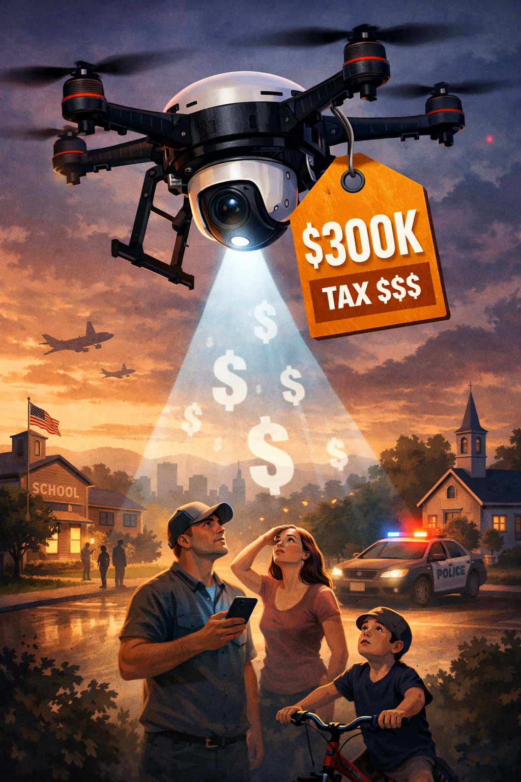
🧠 The cost and intrusion of a neighborhood drone program
This illustration helps residents understand the basic concern: a wide-area drone program can be both expensive and intrusive when policies, limits, and public oversight are not clearly defined in advance.
📄 Primary documents released under Tennessee public records
These files were released through public-records requests and include proposal slides, an email thread, and a map and quote package.
Quick access:
🗺️ Proposed coverage areas in Blount County region
This map image is derived from the public records and reflects the intended coverage zones discussed in the proposal — including residential areas, schools, and corridors that overlap with normal daily life.
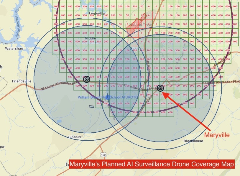
📌 Questions for this coverage area
- Which zones would be flown routinely versus only on calls — and who decides?
- What flight logs, dispatch records, and audit logs would be kept and published?
- Where is footage stored, who has access, and for how long — including non-incident footage?
- Can drone video be searched later to identify individuals not suspected of any crime?
- Would Flock’s drone footage be shared with the Knoxville RTIC or any regional network?
🗣️ Questions residents can ask Maryville and Blount County leaders
- Is any drone program currently being pursued — and what phase is it in?
- What written policy would govern flight authorization, recording, retention, and public reporting before any contract is signed?
- Will drone footage be shared with the Knoxville RTIC or any regional data network?
- What is the estimated annual cost, and what would trigger expansion?
- Will public meetings be held before any contract is approved?
- Given Tennessee’s warrantless drone law, what additional local protections does the City intend to put in writing?
|
❓ Common questions about the proposed drone program
Is this proposal confirmed as approved or active in Maryville?
The public records show proposal-stage discussions. Residents can ask officials for current status, timelines, and any contract or policy documents. Given Knoxville’s approval next door and the Axon-Flock relationship, the question is no longer “if” but “when and under what rules.”
Can police in Tennessee fly drones over my property without a warrant?
Yes, in a range of circumstances. Tennessee permanently extended warrantless drone authority in 2024 (T.C.A. § 39-13-609), including for “reasonable suspicion” of imminent danger, fugitive searches, missing persons, and public property where a crime may have occurred. Courts have generally not extended a reasonable expectation of privacy to areas visible from navigable airspace, including backyards.
How is Knoxville’s drone approval relevant to Maryville?
Knoxville and Maryville are 16 miles apart and share regional ALPR data networks. The Knoxville RTIC integrates public and private camera feeds with drone surveillance — if Maryville’s Flock system or Axon cameras are connected to that network, Maryville residents’ data may flow into the same platform. Additionally, Knoxville’s $37 million Axon contract through 2035 is the model being exported to other East Tennessee agencies.
What should residents demand before any drone contract is signed?
A written policy (published before any vote) covering: flight authorization standards, what areas can be covered and when, data retention periods by footage type, who can access footage and under what standard, whether footage is shared with regional networks or federal agencies, audit logs and public reporting requirements, and explicit limits on use at public gatherings and for non-criminal investigations.
Is this “anti-police”?
No. The ACLU, EFF, and numerous civil liberties organizations have explicitly stated they are not opposed to drones for legitimate purposes like finding missing persons. The concern is governance: written rules, transparent reporting, retention limits, and independent auditing. Chula Vista, California — the first DFR city — publishes a public dashboard of every drone flight. That is what accountability looks like. Maryville and Knoxville residents can demand the same.
|
|||
|
|||
|
|||
|
MaryvillePrivacy.org investigation into the Flock Safety drone-as-first-responder proposal for Maryville, Alcoa, and Blount County, Tennessee. Updated March 2026 to include Knoxville City Council’s January 2026 approval of a $9.4 million, 12-drone program through Axon Enterprise as part of a $37 million contract running to 2035, with a Real Time Information Center. Also covers Tennessee’s permanently extended warrantless drone surveillance law (T.C.A. § 39-13-609, updated 2024), the full spectrum of surveillance integration (fixed ALPR, in-car ALPR, Ring doorbell feeds, RTCC/Fusus, drone-as-first-responder), and Fourth Amendment and First Amendment concerns raised by EFF, ACLU, and civil liberties advocates. Primary documents available including Flock Safety drone proposal slides, email thread, and Blount County regional coverage map and pricing quote.