FLOCK SAFETY ALPR IN MARYVILLE, TENNESSEE
Flock Safety Multi-Geo & Convoy Search
How Flock Safety uses Multi-Geo and Convoy Search to track drivers across cities and states and link vehicles traveling together — and what Tennessee public records show about how these tools are already being used.
|
2+
Cities At Once
Multi-Geo searches plates across multiple jurisdictions simultaneously
|
“PC”
From Travel History
Tennessee training example: “got PC” based on movement pattern alone
|
1,000+
Agencies Networked
Maryville plates searchable across Flock’s entire national network
|
ZERO
Public Rules
No written Maryville policy governing Multi-Geo or Convoy use
|
🚨 Officers Described Claiming “Probable Cause” From Travel History Alone
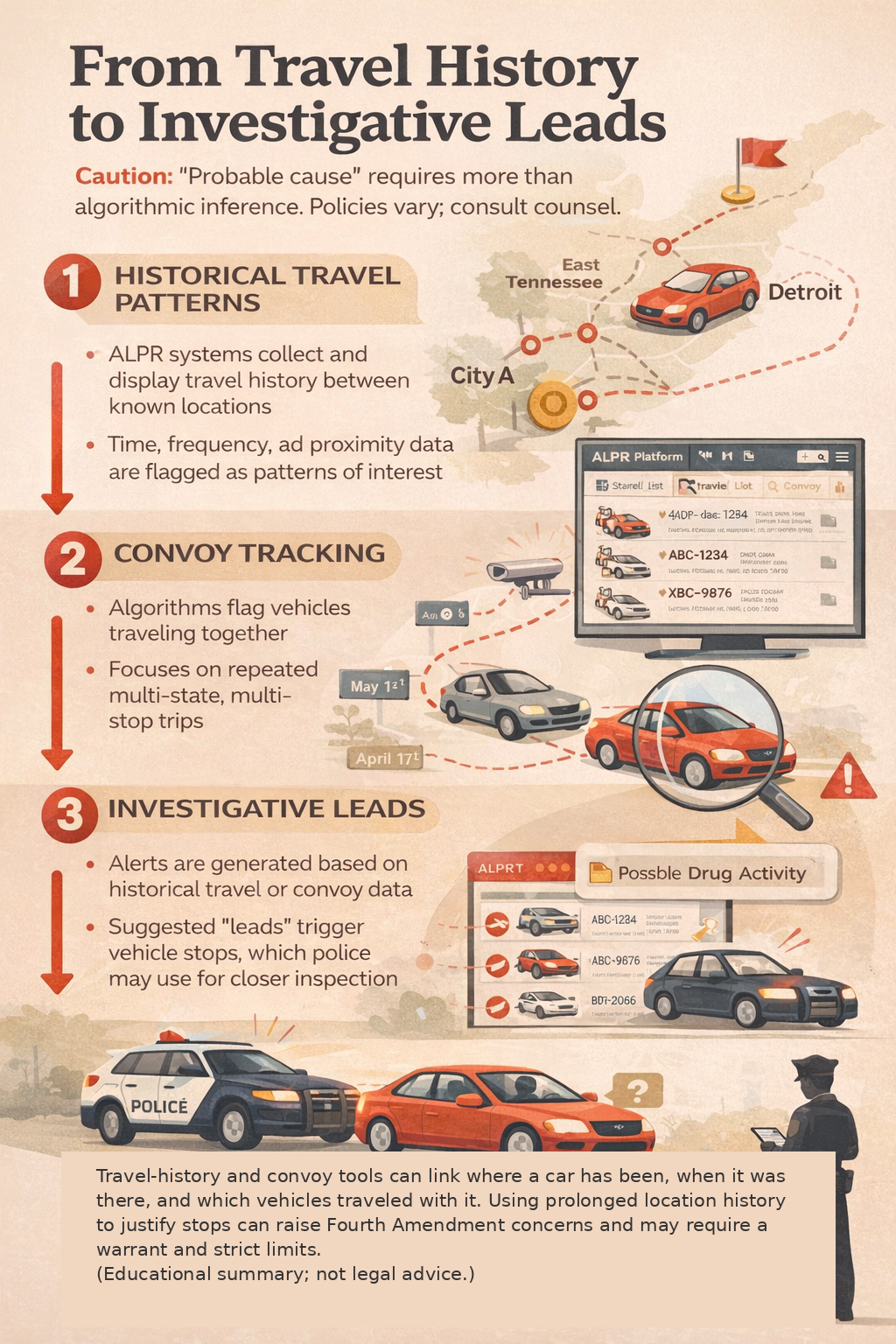
A case summary in the Tennessee training document describes officers reviewing Flock ALPR history showing a vehicle repeatedly scanned in both Detroit and Knoxville. The notes then state the officers “got PC” — probable cause — based on that travel pattern and moved to make a stop.
This matters because the vehicle’s “crime” was its travel route. No observed criminal act. No warrant. No individualized suspicion beyond where the car had been — information gathered passively from cameras that photograph every passing vehicle.
- Maryville’s cameras feed the same national Flock network these tools search.
- If you drive to Knoxville, Nashville, or across state lines, your travel history is queryable.
- There is no public written policy in Maryville governing when or how these searches can be run.
- You will never be notified that your travel pattern was searched or used as a basis for suspicion.
🚨 What These Tennessee Records Show
Newly released public records from East Tennessee show that Flock Safety’s Multi-Geo and Convoy Search features are built to (1) find vehicles that appear in multiple cities within a time window and (2) identify vehicles that travel together. The same training materials include a Tennessee example where officers describe “got PC” (probable cause) based only on travel history.
🧩 How Flock Multi-Geo + Convoy Turn ALPR Hits Into “Pattern of Life”
This infographic is specific to Flock Safety. It also highlights that Flock provides training slides and workflows to police for using Multi-Geo and Convoy — this is vendor-designed behavior, not improvised use.
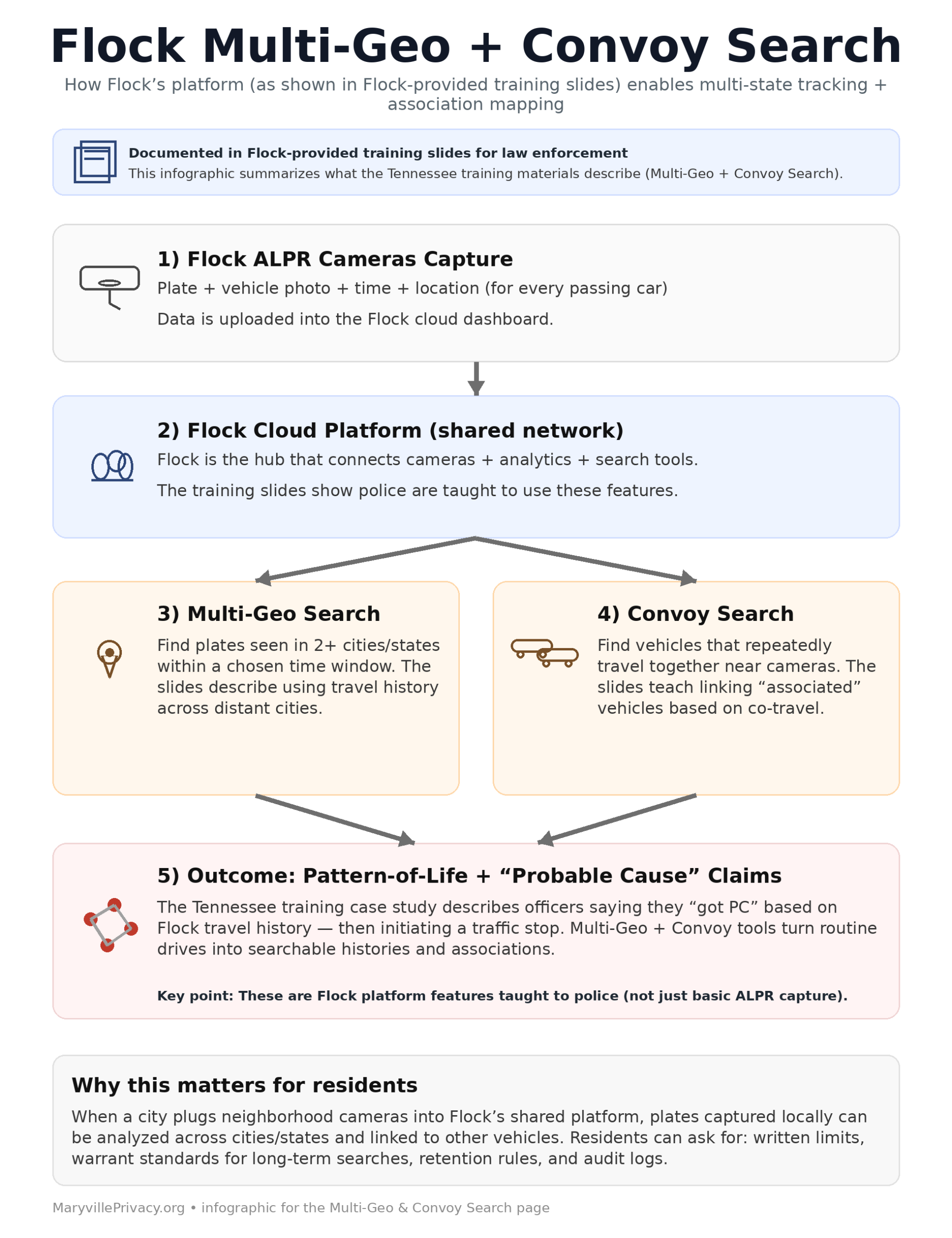
🔍 Multi-Geo Search
- Lets officers choose two or more cities and find vehicles that appear in all of them within a selected time range.
- Works across a shared network of ALPR cameras, turning scattered hits into a cross-city travel query.
- Training examples reference vehicles scanned in both Detroit and Knoxville and flagged for follow-up.
- Once your plate is in the system, it can be queried for appearances anywhere on the network — even if you were never accused of a crime in your hometown.
🚗 Convoy Search
- Looks for vehicles that repeatedly appear near each other at ALPR cameras.
- Flags vehicles as “associated,” allowing investigators to map who a car tends to travel with.
- Case examples describe identifying a second “convoy” vehicle and tracking plate changes over time.
- Works on correlation alone — no criminal act, no warrant, no notification to the people being associated.
⚖️ The Fourth Amendment Was Written Precisely for This
“Good intentions will always be pleaded for any assumption of power. The Constitution was made to guard the people against the dangers of good intentions. There are men in all ages who mean to govern well, but they mean to govern. They promise to be good masters, but they mean to be masters.”
Daniel Webster · U.S. Senator & Secretary of State
Speech at Niblo’s Saloon, New York — March 15, 1837
Amendment IV — Ratified 1791
“The right of the people to be secure in their persons, houses, papers, and effects, against unreasonable searches and seizures, shall not be violated, and no Warrants shall issue, but upon probable cause, supported by Oath or affirmation, and particularly describing the place to be searched, and the persons or things to be seized.”
Multi-Geo and Convoy Search do not require a warrant. They run on a database built by photographing every passing vehicle — not just suspects. Building a searchable cross-city travel history and an association graph of who you drive near, without individualized suspicion, is precisely the kind of unchecked government capability the Fourth Amendment was written to prevent.
|
🏛️ Ruling
|
Court Ruling — Virginia, June 2024 A Norfolk Circuit Court judge ruled that collecting location data from 172 Flock ALPR cameras constitutes a Fourth Amendment search and cannot be used as evidence without a warrant. This ruling directly implicates the kind of travel-history analysis Multi-Geo and Convoy Search are built to perform. |
Maryville residents driving to work, church, or across state lines have committed no crime — yet their movements are logged, cross-referenced, and searchable indefinitely by 1,000+ agencies. The “good intention” of fighting crime does not suspend the Fourth Amendment.
No warrant. No notice. No public vote. No written rules.
🏛️ Agencies and personnel named in the Tennessee document
- Knox County Sheriff’s Office (Knoxville, Tennessee)
- Detective Marcus Parton (listed in the materials as task force / narcotics / SWAT)
- Regional narcotics and task-force work tied to East Tennessee (the slides reference a task-force context)
The presence of Knoxville / Knox County agencies in the slides shows these features are part of regional training — not just a hypothetical marketing pitch. Maryville is part of the same regional network.
📌 The local picture
- Multi-Geo can connect Maryville camera hits to out-of-city and out-of-state travel history.
- Convoy can map who you drive with, not just where you drive — families, coworkers, congregations.
- The Tennessee example shows travel history being treated as enough to claim probable cause for a stop.
- Maryville has no public written policy on retention, sharing, audit logs, warrant standards, or limits on multi-jurisdiction searches.
- Residents will never be notified if their travel pattern is searched or used as an investigative signal.
📄 Read the Multi-Geo & Convoy Search Training Document (PDF)
The PDF below comes from a Tennessee public-records release. It includes screenshots and case summaries describing how Multi-Geo and Convoy Search are used to follow vehicles between cities, build “patterns of life,” and link vehicles traveling together.
One case example describes a stop that followed review of Flock ALPR history, with officers stating they “got PC” based on the travel pattern. This matters because it shows location history being treated as a basis for probable cause rather than just an investigative lead.
If the embedded viewer does not load on your device, open the PDF directly using the link above.
📰 National Reporting: AP Investigation on Vehicle Location Databases
An Associated Press investigation describes how government agencies have relied on nationwide vehicle location databases to follow drivers far from where data was collected. These systems are built from networks of license plate readers and enable long-range searching of travel history.
- Mass collection makes it easy to follow people across many states.
- Travel patterns can be used to generate investigative leads and targets.
- Data-sharing extends access far beyond local voters and local oversight.
- There is often limited public clarity on retention, audit logs, and access limits.
🗣️ Ask local officials for clarity — in writing
If you’re concerned about how Multi-Geo and Convoy tools could be used on drivers in Maryville and Blount County, ask local leaders to:
- Confirm whether local agencies have access to Multi-Geo and/or Convoy Search.
- Publish written policies on retention, sharing, search limits, and warrant standards.
- Release summary statistics (transparency reporting) on how often these searches are used.
- Hold a public meeting before expanding ALPR tracking capabilities or adding new features.
❓ Common questions about Multi-Geo & Convoy Search
Is this just about catching criminals?
The tools run on a database built from scanning everyone who drives past cameras. Ordinary residents, churchgoers, workers, students, and visitors can be swept into the same system even if they’ve never been accused of a crime. The Tennessee example involved a stop initiated by travel pattern — not an observed criminal act.
Does this replace the need for a warrant?
The Tennessee training example describes officers claiming “PC” based on travel history alone. A Virginia court ruled in 2024 that mass ALPR collection constitutes a Fourth Amendment search. Whether courts ultimately require warrants for all uses, residents are justified in demanding clear local rules, auditing, and limits when location history is used to justify a stop.
Does Maryville already use Multi-Geo or Convoy Search?
The records on this page are regional training materials, not Maryville’s internal audit logs. Because Maryville is connected to the broader network, residents can reasonably ask local officials directly whether Multi-Geo/Convoy searches are available and how they’re governed — and request that answer in writing.
Why is this a Fourth Amendment issue?
Long-term automated tracking of someone’s movements and associations can be as intrusive as physically following them for weeks. When systems log routine drives and then mine that history without warrants or individualized suspicion, it looks less like targeted policing and more like continuous surveillance of the entire population.
What should residents ask for?
Written policies, warrant standards for long-term searches, shorter retention where appropriate, strict access controls, audit logs, and regular public transparency reporting that covers Multi-Geo/Convoy usage. Email [email protected] to ask directly.
|
|||
|
|||
|
|||
|
This page is part of the MaryvillePrivacy.org transparency project, documenting how Flock Safety’s license plate reader cameras and tools like Multi-Geo Search and Convoy Search are used in East Tennessee. By reviewing public-records releases, we help residents in Maryville, Alcoa, and Blount County understand how ALPR systems can build travel his