Interactive maps of Flock Safety ALPR surveillance camera locations across Maryville & Blount County, Tennessee — including neighborhood entrances, church roads, school routes, and major intersections.
Maintained by MaryvillePrivacy.org · Last updated March 4, 2026
40–50M+
Vehicle Scans / Year
Based on Maryville Flock dashboards — 26-day sample extrapolated
~99%
Ordinary Citizens
Overwhelmingly law-abiding residents — not criminal suspects
ZERO
Warrants Required
No warrant, no suspicion, no notice — scanned automatically
1,000+
Outside Agencies
Can access Maryville ALPR data per Flock’s own portal
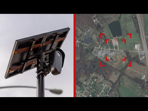
Section 1 · Local Camera Locations
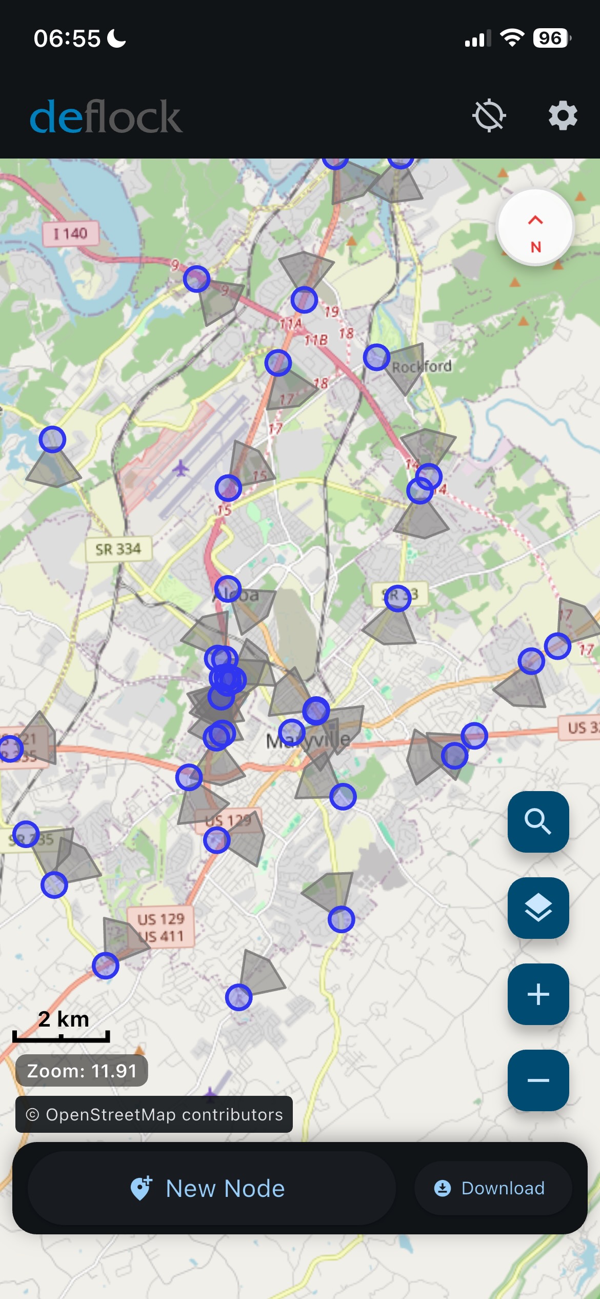
📍 Maryville Flock Camera Map (Blount County, TN)
Known and observed Flock Safety ALPR camera locations across Maryville, Tennessee, based on public observation and city records. Each pin marks a documented camera location.
📌 What you’re looking at: Each marker is a documented or reported Flock Safety ALPR camera location in or around Maryville. These cameras photograph every passing vehicle — regardless of suspicion — and upload your plate, timestamp, and location to Flock’s cloud database, accessible to 1,000+ law enforcement agencies nationwide. See the full investigation →
💡 Locations are approximate. Your email app will open when clicking “Report.”
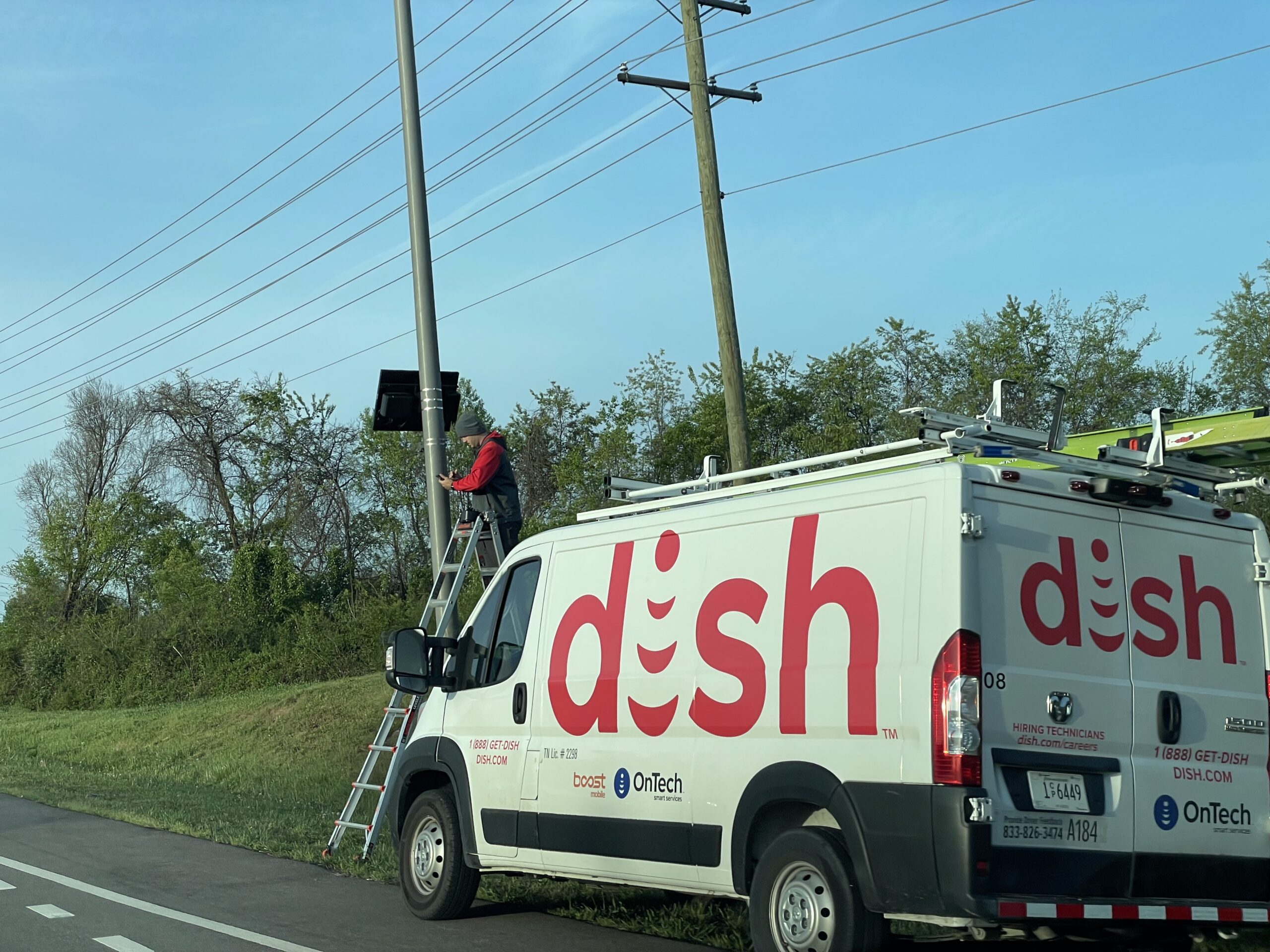
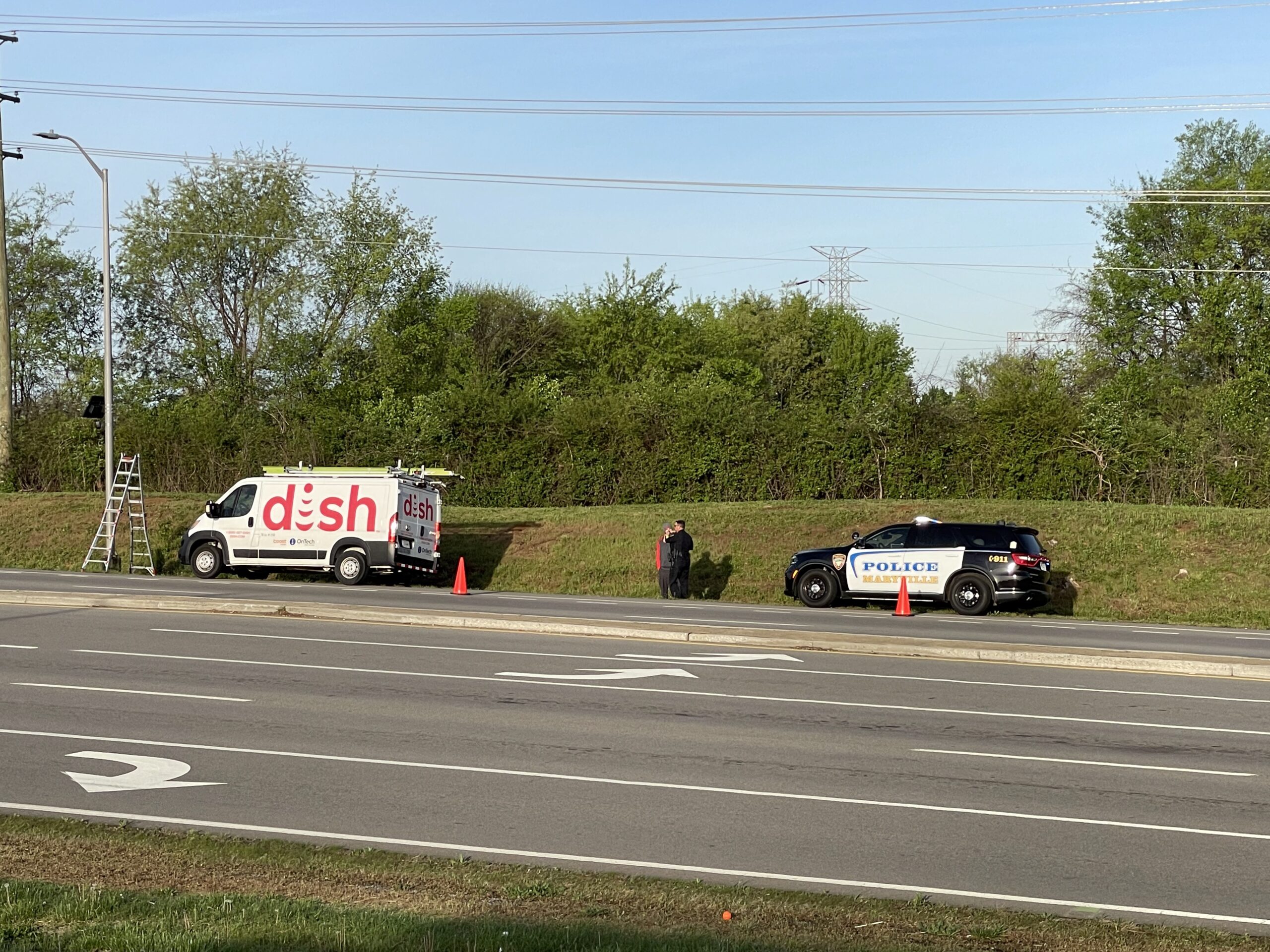
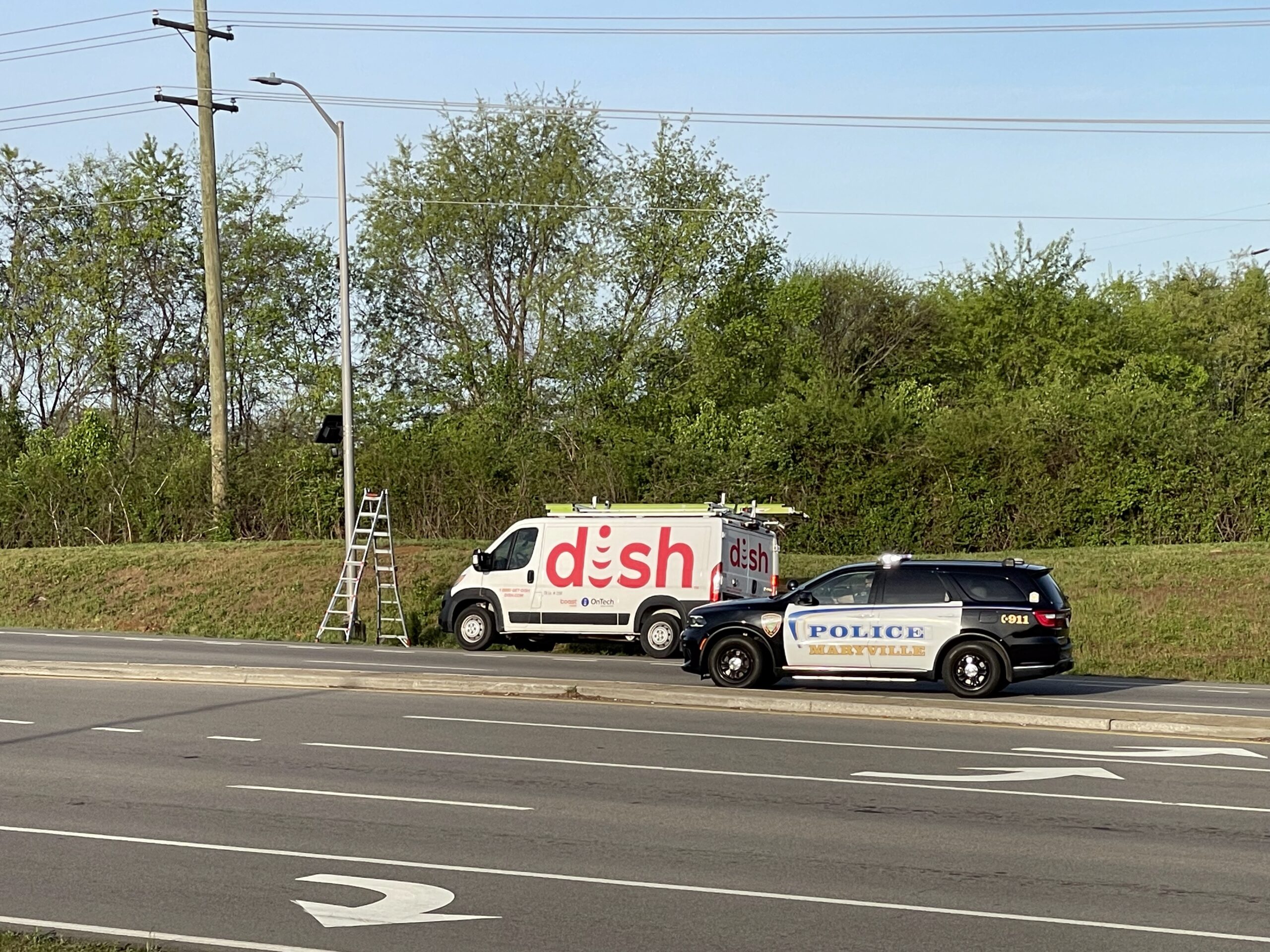
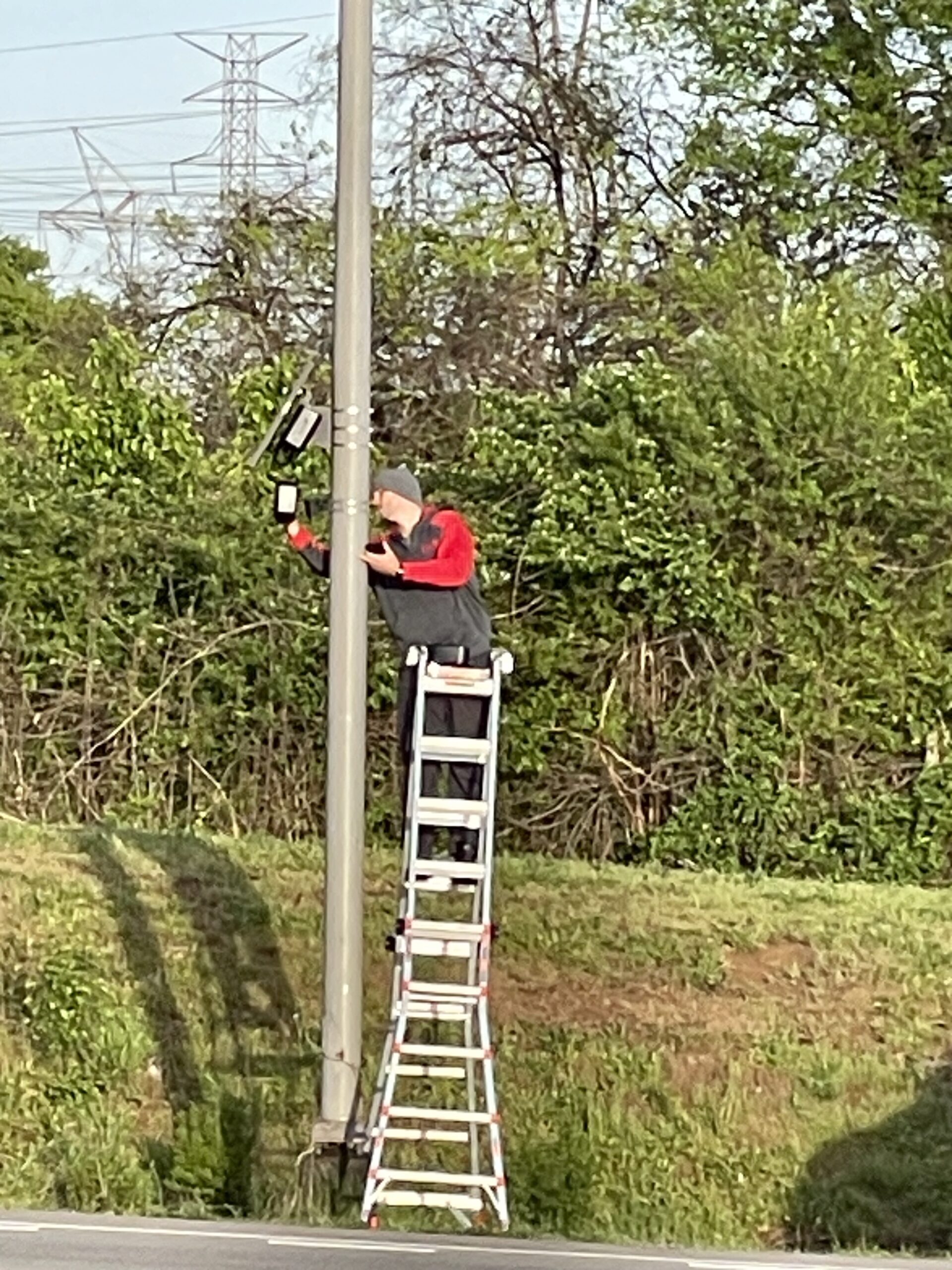
Field Documentation · April 6, 2026
Private Contractor and Police Presence at Maryville Camera Site
On the morning of April 6, 2026, a Dish Network-branded service van and technician were observed and photographed at a Flock Safety camera installation site in Maryville. A Maryville Police Department vehicle was present throughout the work. The photographs below document a private telecommunications contractor participating directly in the installation or servicing of public law enforcement surveillance infrastructure, with sworn officers present on site.
Dish Network van beside a pole-mounted Flock Safety camera unit, Maryville, TN. April 6, 2026.
Maryville Police Department vehicle present on site during surveillance equipment work. April 6, 2026.
Wide view of the site showing contractor van, camera infrastructure, and law enforcement presence. April 6, 2026.
Technician servicing or installing a roadside Flock Safety camera unit near the Foothills Mall area, Maryville, TN. April 6, 2026.
What these photographs show: Flock Safety camera infrastructure in Maryville is not installed or maintained exclusively by city personnel. A private telecommunications contractor was present and working on surveillance equipment at a location covered by police. Residents have not been notified of contractor access to this infrastructure, and no public record has been released identifying which private companies have physical access to Maryville’s surveillance hardware.
Section 2 · Deep-Dive Investigations
📂 What the Public Records Actually Show
These investigations go beyond the map — documenting specific Maryville findings revealed through public records, city emails, and Flock’s own training materials.
Public records reveal Maryville secretly added plates to a Flock “Safe List” — exempting them from alerts. The vehicles confirmed to not be city-owned. No written policy governs this decision.
A Flock training deck obtained through TPRA shows officers taught to build travel histories and flag vehicles traveling near each other — “guilt by travel.” Rarely disclosed to the public.
Flock pitched a countywide “drone as first responder” program at $300K–$600K/year, with planning calls already held with Maryville PD, Alcoa PD, and Blount County Sheriff.
Maryville’s cameras don’t operate alone. This center maps the broader East TN network — which departments are connected, how data flows between agencies, and what the regional footprint looks like.
The July 2, 2024 unanimous council vote that installed Maryville’s cameras — with no public hearing. Profiles of the officials who voted yes and the transparency questions they still haven’t answered.
Explore the broader nationwide network of Flock Safety cameras and other automatic license plate readers — useful if you’re traveling outside Maryville and want to see where ALPR systems have been reported along your route.
This map shows law-enforcement agencies in East Tennessee invited to or coordinated through a Flock Safety “Deep Dive” training event in Sevierville — documented through a Tennessee Public Records Act (TPRA) request.
Vendor-led ALPR “Deep Dive” in Sevierville Agencies on this map attended a regional event where Flock Safety trained officers on its dashboard, data-sharing options, and tools that flag vehicles based on travel history and patterns — not only traditional traffic violations.
💡 Data source: internal email distribution list from a local agency obtained via TPRA. Locations represent agency headquarters, not camera sites.
Section 5 · Avoid Cameras & Report New Ones
📱 DeFlock App – Report Cameras & Plan Camera-Avoiding Routes
The DeFlock web app makes it easy to discover and report automatic license plate readers in your community and offers route mapping to help you avoid known Flock and other surveillance cameras whenever possible.
Quickly add new ALPR camera sightings to the national map.
See plate-reader hotspots before driving through Maryville or East Tennessee.
Generate suggested routes that try to minimize camera hits along the way.
DeFlock is an independent project giving residents practical tools to understand and reduce ALPR surveillance in their daily routes.
Example view from DeFlock showing reported Flock camera locations in and around Maryville, TN.
Section 6 · Learn More
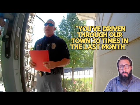
🎥 Videos: How Flock Cameras Work & Why It Matters
These short videos explain how license plate surveillance works, how Flock Safety cameras track and store your movements, and what communities across the U.S. have done about it — all directly relevant to what’s happening right now in Maryville, Tennessee.
How License Plate Surveillance Works A simple breakdown of how ALPR cameras scan vehicles, track movement, and store data — the same system Maryville uses. Relevant to Maryville
Who Is Being Watched? Explores the civil liberties issues raised by widespread ALPR — including the ~99% of scanned drivers who are ordinary law-abiding people. Relevant to Maryville
Flock Cameras Explained A clear breakdown of how Flock captures and stores every passing vehicle. Maryville’s cameras work exactly this way. Directly applies to Maryville
Civil Liberties at Risk Why groups across the U.S. are raising alarms about Flock data being shared, misused, and stored without oversight — the same oversight gap documented in Maryville. Maryville has no written search policy
Centralized Tracking Systems Shows how Flock creates a searchable timeline of everyone’s movements. Maryville’s data is accessible to 1,000+ outside agencies. 1,000+ agencies can see Maryville data
What Other Cities Are Doing Communities that pushed back and successfully removed Flock cameras or won accountability reforms — proof that change is possible in Maryville too. What Maryville residents can demand
False Suspicion: Colorado Case Police tracked a woman’s green Rivian 20 times assuming guilt for a $25 theft. Maryville has no written policy preventing this exact pattern. Maryville has no protection against this
Section 7 · Constitutional Rights & ALPR Surveillance
⚖️ A Constitutional Problem
“
Good intentions will always be pleaded for any assumption of power. The Constitution was made to guard the people against the dangers of good intentions. There are men in all ages who mean to govern well, but they mean to govern. They promise to be good masters, but they mean to be masters.
What Flock Captures on Every Innocent Driver in Maryville
🚗License PlateEvery plate, every pass — stored in Flock’s cloud
🕐TimestampExact time logged each time you pass a camera
📍LocationWhich intersection, neighborhood, or road you used
🔁Travel PatternHow often, which routes — builds a daily profile
👥Associations“Convoy” tool flags who you drive near and when
⛪Where You WorshipChurch, clinic, meeting — all logged without a warrant
U.S. Constitution
Amendment IV — Ratified 1791
“The right of the people to be secure in their persons, houses, papers, and effects, against unreasonable searches and seizures, shall not be violated, and no Warrants shall issue, but upon probable cause, supported by Oath or affirmation, and particularly describing the place to be searched, and the persons or things to be seized.”
Flock cameras photograph every vehicle that passes — not just suspects. Building a searchable timeline of where every law-abiding Maryville resident goes, without a warrant or probable cause, is precisely the kind of unchecked government reach the Fourth Amendment was written to prevent.
🏛️Ruling
Court Ruling — Virginia, June 2024
A Norfolk Circuit Court judge ruled that collecting location data from 172 Flock ALPR cameras constitutes a Fourth Amendment search and cannot be used as evidence without a warrant. The case illustrates exactly what Webster warned: authority expands under the banner of good intentions, one license plate at a time.
Maryville residents driving to work, school, or church have committed no crime — yet their movements are logged, timestamped, and searchable indefinitely. No public vote authorized this. No independent audit oversees it.
The “good intention” of reducing crime does not suspend the Constitution.
Section 8 · The Business Behind the Cameras
How Flock Safety Sells Surveillance
A subscription-based SaaS company founded by Garrett Langley — Flock Safety licenses its ALPR network to governments, businesses, and private communities, creating a shared data ecosystem across all customers.
Founded 2017 · Atlanta, GA · CEO Garrett Langley Annual subscription SaaS model — cameras are leased, not sold. All data flows through Flock’s cloud platform. Valued at ~$3.5 billion (2023 Series E).
The Product
📷 ALPR Cameras + Cloud Dashboard
Solar-powered cameras read every passing license plate, capture vehicle make/model/color, and upload to Flock’s cloud in real time. Subscribers search the database, run travel-history queries, and share reads with other agencies — all via a web dashboard.
Who Pays for Access
🏛️Local GovernmentPolice depts, sheriff offices, city & county agencies. Often funded via grants.Primary customer
🏘️HOAs & CommunitiesHomeowner associations install cameras at entrances — data shared with local police.Shared data
🏫Schools & UniversitiesCampus security deployments monitoring entrances and parking areas.Education
🚁Drone ProgramsAI “drone as first responder” overlay — pitched to Maryville at $300K–$600K/yr.Expansion
🔗Multi-Agency NetworksAgencies opt into data-sharing pools — one subscriber’s reads visible to hundreds of others.Networked
4,000+ agencies nationwide~$100M+ ARR (reported 2023)$3.5B valuation (Series E)30-day default data retentionMaryville, TN — active subscriber
The Data Flow
☁️ Shared Cloud Intelligence
Every plate read from every subscriber feeds the same database. Agencies can search travel history across all networked cameras — not just their own — using Flock’s Convoy and Multi-Geo tools to map who drives near whom, building association graphs of law-abiding residents.
⚠️ The Oversight Gap in Maryville Maryville residents — going to work, school, and church — are tracked without any public vote, data-retention policy review, or independent audit. Flock’s training material obtained by TPRA shows officers told they “got PC” from a vehicle’s travel pattern alone. Read the full investigation →
Common questions about Flock Safety cameras in Maryville, Tennessee and the broader ALPR network, with links to full documentation on MaryvillePrivacy.org.
What is the Flock “Safe List” / ghost vehicle list in Maryville?
Public records show Maryville police use a Flock Safe List / Whitelist / Exempt List to mark some plates as “trusted,” allowing those vehicles to bypass many alerts. At one point the list contained only three plates — later confirmed to be not city-owned vehicles, meaning private cars received special treatment inside the system.
How is Flock training police to use travel history and “convoy” tools?
A Flock Safety training slide deck obtained through TPRA in East Tennessee shows officers taught to use Multi-Geo and Convoy tools — building travel histories and association patterns (who you drive near and when). A Tennessee scenario in the deck tells officers they “got PC” largely from a vehicle’s travel pattern. That is the “guilt by travel” concern documented on this site.
Is Maryville considering Flock AI drones or “drone as first responder” programs?
Yes. Flock Safety has pitched an AI “drone as first responder” program to Maryville in the $300,000–$600,000 per year range, depending on options — layering aerial surveillance on top of existing license-plate readers.
How can I find, report, or avoid Flock cameras in my area?
For Maryville and Blount County, start with the interactive Maryville Flock Camera Map on this page. To report new locations or generate camera-avoiding routes, use the independent DeFlock app, which crowdsources ALPR locations nationwide.
Who approved Maryville’s Flock cameras and was there a public hearing?
The Maryville City Council voted unanimously on July 2, 2024 to approve a resolution titled “A Resolution Approving the Installation of LPR/Cameras in Maryville, TN for the Purpose of Public Safety.” There was no public hearing and no community notice before the vote. See the full accountability report including council member business connections →
Can I contact city officials about Maryville’s Flock cameras?
This page is part of a local citizen project in Maryville, Tennessee, documenting how Flock Safety ALPR cameras, ghost vehicles, and potential drone programs affect the everyday movement of law-abiding residents going to work, school, and church.